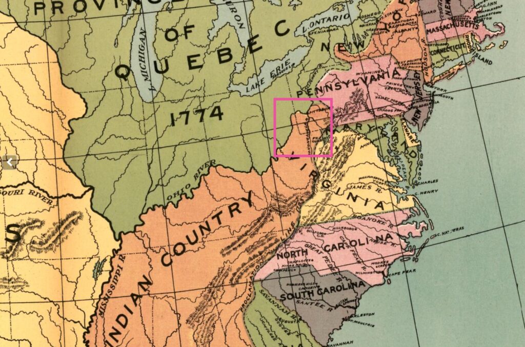
In the decade after the French and Indian War, the frontier around Fort Pitt and the future site of Wheeling—standing at the edge of the Ohio Country—buzzed with uncertainty. For colonists, the undertones carried equal parts promise and peril. This was contested ground, marked by past raids, shifting alliances, and overlapping colonial claims. Native communities such as the Shawnee, the Ohio Haudenosaunee (often called Mingo), and the Lenape still hunted, camped, and moved along the river, even as Pennsylvania and Virginia jockeyed for jurisdiction and surveyors prepared to carve the valleys into plats and patents. Traders drifted down from Pittsburgh, and the small administrative detachments Britain left behind at Fort Pitt kept uneasy watch after larger garrisons were withdrawn during the cost-saving troop reductions of 1763. Meanwhile, speculators far from the valley studied colonial surveys, traders’ sketches, and military reconnaissance reports, calculating what might soon be taken.
For some, this was a landscape of instability and danger. For others, it was a ledger of opportunity. George Washington understood it as both. He had fought here, nearly died here, and now hoped to profit here.
Drawn West
In 1753, George Washington—twenty-one years old, a son of Virginia’s planter elite, and a minor stockholder in the Ohio Company—was selected by the colony’s governor to carry a message west. It was his first real chance to make his mark. Years earlier, his older half-brothers had tried to secure him a place in the Royal Navy, but his mother refused; now he was a grown man, unencumbered, ambitious, and eager to prove himself.
Washington’s first journey into the Ohio Country began at Cumberland, Maryland, in the company of the seasoned frontiersman Christopher Gist. Gist knew the region well: he had scouted the Forks of the Ohio for the Ohio Company and helped identify the site where the British hoped to build a fort. That unfinished work would soon be confronted and compelled to surrender when a large French force arrived in 1754 to tear down what the British had begun and construct Fort Duquesne at the Fork of the Ohio River. Once the French planted their stronghold at this strategic confluence, Britain’s claims of sovereignty were effectively trampled.
In the months leading up to that confrontation, sending a young officer like Washington west was seen as prudent. He was expected to recognize the stakes, deliver Virginia’s warning to the French, and, just maybe, deter their ambitions before the frontier slid into open conflict. Together, they crossed the Alleghenies and reached the Forks of the Ohio River.
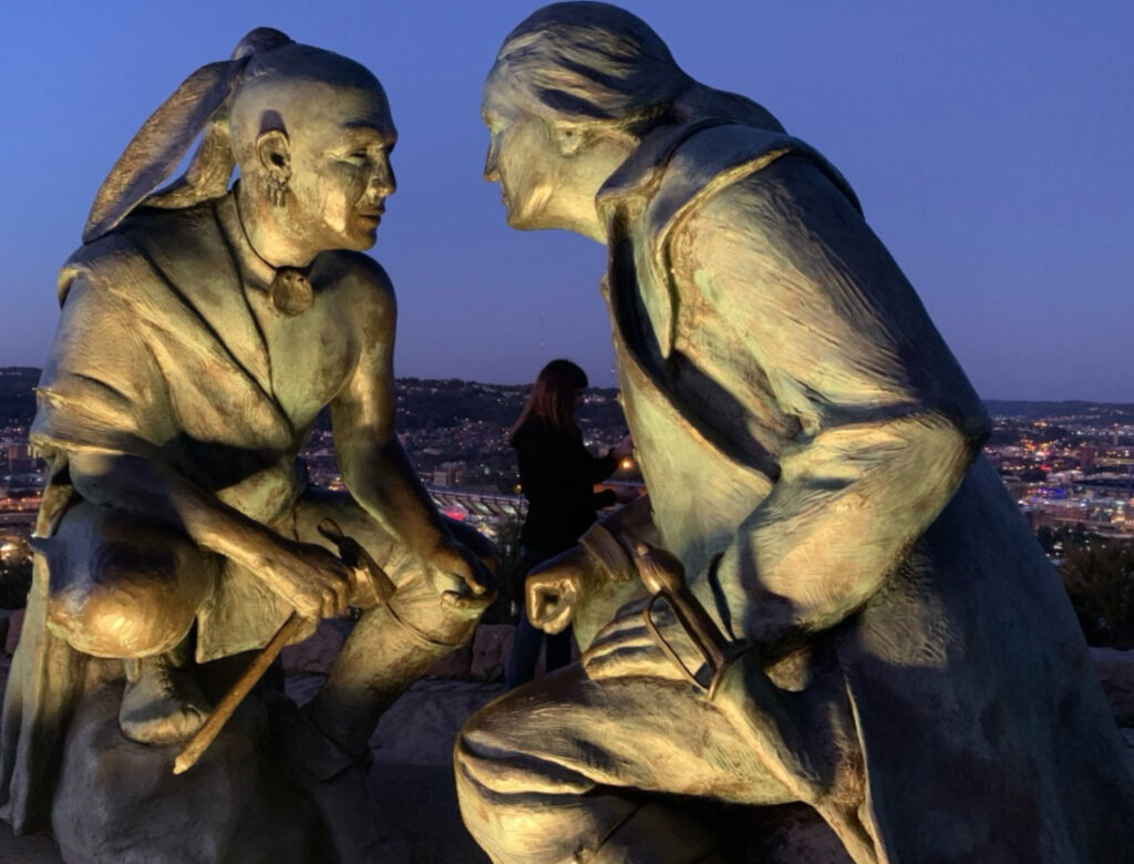
At Logstown, Gist introduced Washington to Tanacharison[1], the Seneca leader known as the “Half King.” Although nominally allied with the Haudenosaunee Confederacy, Tanacharison operated with relative independence in the Ohio Country, where he watched the steady advance of French influence with deepening alarm. Some sources refer to the Half King as a “Mingo.” He was indeed a Seneca living in the Ohio Valley, but that misses the point. Tanacharison held a position created by the Grand Council at Onondaga — a vice-regent sent west to assert Haudenosaunee authority. To call him a “Mingo” because he was in the Ohio River Valley is like calling General Thomas Gage an American because he lived in the colonies. Both men resided on the frontier, but both represented outside power. However, Tanacharison was also more than just a representative. The Six Nations had declared neutrality regarding the French and British. By supporting Washington, he made an independent choice. Tanacharison agreed to escort Washington north to deliver Governor Dinwiddie’s message to the French garrison at Fort Le Boeuf.
Guyasuta (also spelled Kiasutha), another prominent Seneca and seasoned intermediary in the region, who had previously worked as a guide for British expeditions, also played a role in helping Washington navigate the area. Washington refers to Guyasuta as “the hunter” in his 1754 journal.[2] Though less politically aligned with the British than Tanacharison, Guyasuta had deep knowledge of the terrain and relationships with multiple Native communities along the river corridors.
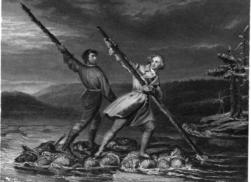
As discussed in Part I of the series, Washington’s mission to Fort Le Boeuf ended in failure. On the return east, in the dead of winter, as he and Christopher Gist were trying to pole a crude raft across the swollen Allegheny River, ice floes jammed the craft and pitched Washington headlong into the freezing current. Gist pulled him to safety, saving his life, and perhaps the future of the Virginia frontier with it. It can almost be said that the man who would become the first American president was baptized in those icy waters of western expansion, where he caught the land fever that would shape so much of his career.
Washington’s second trip west, in 1754, was no longer diplomatic but military. Now leading Virginia militiamen, he again aligned with the Half King Tanacharison, and together they ambushed a French detachment led by Joseph Coulon de Jumonville. Jumonville’s death—reportedly at Tanacharison’s own hand—transformed the skirmish into an international incident and helped ignite the broader conflict known as the French and Indian War. Washington pulled his force back to a clearing called the Great Meadows and hastily erected a small stockade he named Fort Necessity. It was little more than a palisade ringed by a shallow trench, thrown up in anticipation of French retaliation.
In the wake of Washington’s surrender at Fort Necessity in July 1754, French forces swept down the Youghiogheny Valley and destroyed Gist’s plantation, including his fortified storehouse and home. This effectively ended Gist’s foothold in the Ohio Country. Though some later claimed the destruction was retaliation for his alliance with Washington and the Ohio Company, in truth, it was likely because Gist’s property stood as the most exposed Anglo-American outpost in the valley, a target the French could not leave standing.[4]
Marching In Step to the Map-Grid
By his early twenties, Washington had crossed the Alleghenies multiple times and was intimately familiar with the route into terrain, the politics of Native diplomacy, and the logistics of long-distance backcountry travel—skills few of his Virginia peers could match. In 1755, now a provincial colonel, Washington rendezvoused with General Edward Braddock at Frederick, Maryland, where he accepted a volunteer position as aide-de-camp. This expedition was eye-opening for both British regulars and colonial provincials. Braddock’s army had been shipped directly from Ireland, and few among them, or their provincial counterpartsm, fully understood the geographic realities of the interior.
From the beginning, plans unraveled. Philadelphia’s port was the premier harbor of North America, but Virginia’s tidal Potomac River seemed the more alluring artery. From the Chesapeake up through Alexandria and modern Georgetown, it was broad, deep, and navigable for ocean going vessels. The British imagined that same river would carry their British army straight to the defeat of Fort Duquesne and the restoration of the Forks of the Ohio.
Braddock’s army did not land at Alexandria, though it was the Chesapeake’s rising port city. Its wharves handled immense tobacco exports and a steady trade in enslaved Africans, a commerce that would soon make Alexandria one of the largest slave ports in North America. Instead, the general brought his men upriver to a sandstone quarry beside what is now Constitution Avenue, where the firm footing of what is now known as Braddock’s Rock made a better landing for cannon and wagons. The choice was practical, not moral. Yet the decision meant that Braddock’s first steps into the American interior were made in sight of stone and river, rather than the crowded docks where men, women, and children were sold like cargo.
Unfortantely for Braddock’s force, maps in London greatly over-exaggerated the utility of the Potomac as a throughfare. Reconnaissance quickly revealed the fatal obstacle: the Falls of the Potomac (now Great Falls State Park) could not be portaged. It was the first of three major natural barriers before even reaching Mecklenburg (modern Shepherdstown, WV), where the Pennsylvania wagon road crossed the Potomac. If they were going to reach the interior, it would have to be overland.
Looking back, the dream that the Potomac might reach the Ohio did not die with Braddock’s column. It haunted American development well into the nineteenth century, only to collapse under its own weight with the Chesapeake & Ohio Canal—a project crippled by floods, costs, and the simple geography that no engineer could erase.
After assembling in Frederick, Maryland, the combined force moved southwest, crossing the Potomac at Mecklenburg via the Swearingen Ferry. The army then gathered at Winchester, Virginia, where Quartermaster General John St. Clair oversaw the mustering of wagons, provisions, and provincial troops. From there, the force pushed west. No wagon road yet existed beyond Winchester, but the trail they followed was an ancient Native path known as Nemacolin’s trail. Braddock’s engineers and axemen carved the route as they went, hacking out the first overland military road through the Alleghenies toward the Ohio.
St. Clair had pushed hard for a direct road west from Winchester—not out of ignorance, but urgency. He feared the French would receive reinforcements if the British did not act quickly. While later critics blamed St. Clair for the slow pace, the real problem was Britain’s insistence on moving a European-style army—with artillery and heavy wagons—through mountainous terrain. Under such conditions, a slow march was inevitable.
As a young surveyor for Lord Fairfax, Washington learned early how much geography mattered. What Braddock’s march revealed as fatal ignorance, he would later transform into doctrine. Maps would no longer be ideas sent from London but tools of survival and conquest in America. The disaster left Washington with a lesson that shaped the rest of his career. Braddock’s army had stumbled blind into the interior, guided by maps that glossed over obstacles and by officers who mistook imagination for knowledge. Washington saw that victory in America would depend not only on muskets and cannon, but on mastering the land itself. Two decades after Braddock’s defeat, the commander of the Continental Army fought the Revolution with that surveyor’s eye. In 1777, he institutionalized the lesson, making trained geographers and surveyors essential to his staff and appointing Robert Erskine as Geographer and Surveyor General of the Continental Army.
Washington’s Trip Down the Ohio
In 1770, George Washington passed through what Anglo-Americans called Mingo Town, a settlement about seventy miles below Fort Pitt and upriver from where Wheeling would later stand.[7] By then, he was still addressed as “Colonel Washington,” but his militia service was behind him—at least for the moment. A year earlier, he had married the wealthy widow Martha Custis, thereby gaining managerial control of one of Virginia’s great estates, though he did not own it; he remained the legal proprietor only of the lands he already held before the marriage.
This journey was neither military nor sightseeing. Every earlier trip west had been in some official or semi-official capacity. In 1770, personal ambition drove Washington. He was surveying. According to his journal, Mingo Town had about 20 cabins and 70 inhabitants, drawn from six tribal nations. Washington noted these details not out of curiosity but calculation. As a rising political figure, he was actively lobbying for land grants on behalf of Virginia’s provincial veterans of the French and Indian War, including himself.
Perhaps Christopher Gist had rubbed off on him during that icy winter years before. Once a soft-handed envoy in his brother Lawrence’s borrowed uniform, Washington was now learning to read rivers, interpret forests, and survey landscapes for the outlines of his own speculative ambition.[8] Like many elites of his generation, he viewed the West as earned, not claimed. He had fought for it, and now he intended to possess it. His journey down the Ohio was a reconnaissance mission—for land, for leverage, and perhaps even for legacy.
Further down the Ohio, Washington noted another site: Grapevine Town, a seasonal hunting camp near the mouth of Wheeling Creek, some thirty-eight miles beyond Mingo Town. It appeared to be occupied by a small group of male hunters, likely accompanied by women. The settlement reflected a typical Indigenous pattern—seasonal occupation tied to resource use—rather than permanent village life. One anecdote from this segment of the journey captures the early colonial spread of misinformation. Earlier, while within Mingo Town, Washington reported hearing that two traders had been killed at Grapevine Town. Upon investigation, however, he learned only one man had died—and he had drowned while attempting to ford the river at an ill-advised crossing.[9]
On this same expedition, Washington also crossed paths again with Guyasuta, the Seneca leader who had guided him over a decade earlier. In the Seven Years’ War, Guyasuta had fought for the French and helped deliver the devastating blow at Braddock’s defeat in 1755, of which Washington was one of the few British survivors. Their paths had diverged: Washington was now a Virginian land speculator with a rising political career, while Guyasuta had become a seasoned warrior and strategist navigating between empires. In the years ahead, he would assume a diplomatic mantle, playing a pivotal role in Lord Dunmore’s War, where, like the Lenape leader White Eyes, he sought to keep the Six Nations neutral as Anglo-American expansion threatened to ignite a broader Native war.
By the time of his 1770 journey down the Ohio River, George Washington was no stranger to legal entanglements. He understood the chaotic web of overlapping land claims, vague colonial charters, and endless surveying disputes; not just in theory, but out of necessity. Securing land in the backcountry required more than ambition; it demanded fluency in the legal and political chaos of westward expansion. When Pennsylvania opened lands west of the Alleghenies in 1769, Washington acted swiftly. Working through his trusted agent William Crawford, he began quietly maneuvering to secure valuable plots in the Kanawha region—positioning himself ahead of the speculative rush.
Land Magnates
By 1783, half of Bedford County, Pennsylvania, was owned by speculators who had never set foot there. The people who lived there—actual settlers, tenant farmers, merchants—often held no claim to the land. [10] Washington aspired to join the ranks of the former: investors who let others do the clearing while they watched the value of their claims rise from a distance. His trip down the Ohio in 1770 was not simply the wanderings of a curious veteran but the groundwork of a man entering the speculative class. He saw Native towns and unmarked meadows as future surveys.
He had the ambition and the network to accomplish this mission. Trusted agent William Crawford’s support, especially, would allow Washington to position himself ahead of competitors. Washington’s connection to Crawford went back to Braddock’s campaign in 1755, where both men served in Virginia’s militia. Crawford later settled on the Youghiogheny and became a skilled surveyor. Washington saw in him the perfect agent—someone with local knowledge and official authority who could secure claims while Washington himself stayed in eastern Virginia. By the 1770s, Crawford was firmly Washington’s man on the ground, positioning the latter ahead of the oncoming rush of settlers. And a rush it would be.
Bedford County, firmly under Pennsylvania’s control, shows how quickly land could be swallowed by absentee speculators—by the early 1780s, half the county was already locked up on paper. However, across the Monongahela, the picture was different. What Pennsylvania called Westmoreland County and Virginia called the District of West Augusta was a disputed borderland. Rival courts issued competing patents, sheriffs collected taxes for two governments, and settlers never knew which claim would stand. When Pennsylvania finally carved out Washington County in 1781, the tax list reflected that difference: unlike Bedford, the land here was not yet dominated by absentee magnates but still being fought over on the ground. For prospective speculators like George Washington, Bedford showed the reward, and the Monongahela country showed the opportunity. The turmoil that left farmers unsure of their titles gave speculators like Washington leverage, and it was in these borderlands—between empires, colonies, and states—that fortunes could be made.
Figures like John Wagle, who sent repeated letters to Baynton, Wharton & Morgan on behalf of New Jersey-based would-be speculators, remind us that land was a commodity. The same Philadelphia merchant firm that managed shipping routes from privateer-infested Kingston waters to Lisbon was also approached for credit in the Ohio Valley. Whether importing Malaga wine into Philadelphia Harbor or arranging deeds for New Jersey emigrants, Baynton, Wharton & Morgan dealt in commodities, and land was one of them.[11] This was the world Washington wanted to enter at the forefront: not the isolated settler clearing trees, but the men who turned land into leverage.
What about the Native peoples? Washington’s recording of Mingo Town and Grapevine Town, along with his meeting with Guyasuta, reveals that although many Native communities did not occupy these Ohio River Valley sites year-round, they were far from vacant. These sites appeared sparsely inhabited and thus ripe for future claims. But for Native nations, they were part of a broader cultural and territorial landscape—a living network of mobility, memory, and meaning that defied colonial property lines.
The line between ownership and occupation was murky. For colonial elites, land meant power. For Native peoples, it meant survival. And for settlers, tenant farmers, and former soldiers hoping to claim a foothold in the West, it meant navigating broken promises, legal confusion, and the quiet advance of wagons, boots, and axes—moving tree by tree, acre by acre.
Notes & Citations:
[1] Colonial sources sometimes refer to more than one “Half King.” In Pennsylvania records from the 1740s and early 1750s, the Oneida spokesman Scalooyady carried that title, addressing treaty conferences in Lancaster, Carlisle, and Philadelphia before dying of smallpox in 1757. The “Half King” Washington encountered, Tanacharison, was a Seneca appointed by the Grand Council to oversee Iroquois interests in the Ohio Valley. The title was not a personal name but a political office — a kind of vice-regency — which helps explain why more than one leader bore it. Additionally, the title Half-King had no meaning outside colonial circles whom had coined the title.
[2] George Washington, The Journal of Major George Washington (1754), ed. Paul Royster, Electronic Texts in American Studies, no. 33 (Lincoln: University of Nebraska–Lincoln), accessed [insert date], https://digitalcommons.unl.edu/etas/33/13.
[3] Washington Crossing the Alleghany, engraving after Daniel Huntington, 1845. Public domain via Wikimedia Commons.
[4] In the colonial period, “plantation” referred broadly to a farm or settlement. Christopher Gist’s “plantation” on the Youghiogheny was no grand estate — it was a frontier homestead and trading outpost. Only in the 19th century did the word acquire the southern associations of vast slaveholding estates that it carries today. Yet slavery was already present in the backcountry. Men of means such as the Gists and the Cresaps practiced enslavement, carrying the institution westward with them, even as they presented their settlements as rough frontier outposts.
The burning of Gist’s Plantation in 1754 ruined Christopher Gist. The Ohio Company’s outpost was gone, and Gist himself never recovered, dying five years later in South Carolina. Yet his sons carried the frontier mantle he had first shouldered. Nathaniel Gist in particular became a collaborator and contemporary of Daniel Boone, raising a corps of frontier scouts and carrying his father’s name deep into the Revolutionary era.
[5] St. Clair’s axemen carved a military road, about two wagons wide, through the Alleghenies — the first of its kind into the Ohio Valley. Road building was laborious work outside of the duties of British soldier so they were eligible to make an extra 6 pence a week performing the task.
[6] Braddock’s Trail became known as the National Road in the early 19th century, when it was rebuilt as the first road constructed with federal funding. Congress authorized the project in 1806, re-using much of Braddock’s original route and extending it westward from Cumberland, Maryland. Today, the historic roadway survives as part of U.S. Route 40, which notably connects Baltimore, Maryland, to Wheeling, West Virginia.
Douglas R. Cubbison, On Campaign Against Fort Duquesne: The Braddock and Forbes Expeditions, 1755–1758, through the Experiences of Quartermaster Sir John St. Clair (Jefferson, NC: McFarland, 2015).
[7] W.H. Hunter. “The Pathfinders of Jefferson County.” Ohio Archeological and Historical Quarterly 6, no. 2 & 3 (April & July 1898). 115.
[8] Washington Irving (in his multi-volume Life of George Washington) mentioned George having a uniform ready when he received his appointment — possibly implying it was his brother’s. Lawerence Washington died of tuberculosis in 1752, before his brother George journeyed west.
Washington Irving, Life of George Washington, vol. 1 (New York: G.P. Putnam and Co., 1855), 106–107.
[9] Washington. “The Writings of George Washington; Being His Correspondence, Addresses, Messages, and Other Papers, Official and Private, Selected and Published from the Original Manuscripts with a Life of the Author, Notes and Illustrations.” 523.
[10] Jackson Turner Main. Social Structure of Revolutionary America. Princeton, NJ: Princeton University Press, 2015.
[11] John Wagle to Baynton, Wharton & Morgan, [date], Baynton, Wharton & Morgan Papers, Collection 1719, roll 2235, Historical Society of Pennsylvania, Philadelphia
For readers who wish to follow ongoing research, subscription is available in the footer.