
From the Allegheny highlands to the Shawnee towns near the Scioto, the Ohio River Valley unfolded as a chain of river bottoms, upland forests, cane thickets, and ancient trails shaped by centuries of footfall. Today, much of that landscape is overshadowed by post-industrial decline — a far cry from the dense cultural world that once animated the region. The Ohio Valley’s importance did not arise suddenly in the Industrial Age. Its rise as America’s steel and manufacturing core echoed the same geographic advantages that made it contested in the colonial era: rich resources, dense river networks, and its position as a continental crossroads. What changed was not the geography but the scale and technology of exploitation.
Within a century of the British conquest of the Forks of the Ohio after the destruction of Fort Duquesne, Pittsburgh would cross the threshold from a frontier manufacturing town to the heavy-industrial city that would reshape American history. In the lifespan of a single individual, the Ohio River Valley transformed from the last major eastern refuge where multiple Native nations converged into the industrial heart of an Anglo-American republic. How did this world-changing epoch take shape? The transformation began as colonial settlers entered the valley’s contested enclaves, triggering a cycle of land speculation, warfare, treaty diplomacy, and resource extraction that eventually created the conditions for industrial development.To understand what the Ohio Valley became, we must first understand what it was. Every story begins somewhere, and this one begins long before settlers crossed the mountains. For centuries, geography shielded the valley; once the gates opened, epidemics poured through as relentlessly as settlers themselves
Not Eden, Not Empty—Something More
The Ohio River Valley was never an empty wilderness. It was a lived corridor of Shawnee hunting grounds, Lenape towns, Haudenosaunee trails, and sacred sites that tied people to place across generations. Shielded behind the Appalachian ridges, the valley functioned like a geographic basin shaped by river corridors, seasonal movement, and intertribal networks. Before sustained European settlement, it formed a self-contained Indigenous world—not empty and not idyllic, but internally oriented, with its own conflicts, alliances, and trade routes.
Europeans chased rumors of golden cities, yet the continent’s most enduring wealth lay in places like the Ohio Valley: rivers, fertile bottomlands, hardwood forests, and—later—coal and iron. Native nations understood this landscape long before colonists arrived. Native communities foraged and cultivated edible and utilitarian plants: wild plums and cherries, native grapes, maize, and stands of oak, hickory, beech, maple, and buckeye. Medicinal plants such as sassafras, ginseng, sarsaparilla, goldenseal, and witch hazel were integral to Indigenous healing traditions long before Europeans adopted them.
Some of these plants fed global markets. Sassafras entered European trade by the early 1600s, praised as a treatment for venereal disease. But no plant gained the prominence of ginseng. By the 1770s, “sang,” as settlers called it, had become a frontier commodity gathered across the Alleghenies and traded eastward. In 1784, the Empress of China sailed from New York with a hold full of American ginseng bound for Canton—one of the new nation’s first exports to China, marking the start of a trans-Pacific trade that rivaled the fur trade in value.
Yet settlers rarely saw the valley’s abundance as wealth in itself. Lacking a commercial forestry industry, they viewed old-growth forests as obstacles to clear rather than resources to harvest. And although Native healers used complex botanical knowledge, colonial medicine remained rooted in European practices such as purging and bloodletting, leaving much of that knowledge unrecognized. What settlers did recognize was land. The Ohio Valley contained a vast expanse of territory—roughly five percent of what would become the modern United States—structured not by European deeds or borders but by Indigenous occupation, alliances, and stewardship. To colonists, this absence of European title signified potential; to Native nations, it was home.
Terra Nullius
When Europeans entered the Ohio Country in the eighteenth century, they found not an empty land but a populated and well-traveled landscape—home to Shawnee, Lenape, and Haudenosaunee-connected towns. What settlers struggled to understand was that Native presence in the valley was historic but not static. No single nation traced an unbroken lineage in the region from pre-contact mound-building societies to the eighteenth century, yet that did not mean the land lacked roots or belonging. The Ohio Valley had long been a shared, shifting cultural space shaped by migration, displacement, warfare, and alliances.
Yet while these eighteenth-century communities were recent arrivals in political terms, the valley itself bore signs of much older human presence. Across its river terraces lay the remnants of Adena, Hopewell, and Fort Ancient societies—earthworks, burial mounds, and ceremonial landscapes that predated the Shawnee, Delaware, Mingo, and Haudenosaunee-affiliated communities by centuries. The peoples of 1770 were not the direct heirs of those builders, yet they lived among their creations. Archaeology suggests that many travel corridors in the Ohio Valley—especially along the Scioto, Muskingum, and lower Kanawha—have been used for millennia. The nations who rebuilt their lives there in the eighteenth century were not entering untouched land; they moved along routes inscribed by older societies.
Some have suggested a parallel between the Shawnee’s mobile relationship to the land and that of the Fort Ancient, but the Shawnee and other Native nations of the eighteenth century did not claim the mounds as their own. However, there is zero archaeological, linguistic, or cultural evidence linking the historic Shawnee to the Adena, Hopewell, or Fort Ancient builders. In the nineteenth century, Shawnee representatives explicitly told interviewers their people had no memory of who built the cairns and earthworks. That silence mattered: it marked the builders as belonging to an earlier world, now beyond living memory.[2]
Yet settlers misread this silence. Settlers saw ruins without descendants and people without “fixed” homes. From this, they invented an empty landscape. In reality, the Ohio Valley was neither abandoned nor unclaimed — it was a living cultural corridor.
To eighteenth-century eyes, land without a European flag was land unclaimed. Never mind the trails, council sites, or sacred mounds—none of these mapped easily onto their notions of sovereignty or ownership. Out of this misreading emerged the fiction of terra nullius—land without an owner—when in reality the Ohio Valley was still a cultural and political corridor alive with Native use and meaning.[3] The land was inhabited. The land had always been inhabited. The only people who imagined otherwise were those who needed emptiness to justify possession.
Corridors
In reality, the Ohio Valley was anything but empty: it was mapped in trails, marked in trees, and memorized in stories. The world of the Native peoples was a world of corridors, traced along ancient pathways. Overland, these trails had been tested and refined for generations—possibly reaching back to the Adena, Hopewell, and later Fort Ancient peoples—the land itself teaching which passages were possible and which were not. In time, footpaths became well worn roads. The waterways, shaped by natural forces, were equally critical for travel and trade. To outsiders unfamiliar with them, the Ohio Valley seemed wild and uncharted. To those who lived there, it was a memorized system of paths, a network as precise and enduring as any map.
Bent saplings marked Native trails that, over generations, grew into full sized trees pointing the way. Like the nearby mounds and cairns, they stood at the very places where people moved most often. When settlers widened those paths into wagon roads and later into highways, the markers and the mounds alike vanished beneath the advance of “progress.”
Gates of the Ohio
Perhaps today we don’t fully appreciate the formidable barrier the Appalachian Mountain range presented, but that certainly wasn’t an option for the people of the region’s prehistory. Modern West Virginia, often referred to as the Mountain State, is situated entirely within the Appalachian Mountains. The Ohio Valley was never “open land.” The Ohio Valley was not an open canvas, not a flat grid to be measured into rectangles. It was already a landscape of nations and shaped by rugged terrain. The Appalachians stood before it like a natural wall—not sealing it off, but channeling movement through narrow passes and river valleys. Peoples did not simply wander into it from the east. The mountains themselves did the work of borders. A farmer in eastern Virginia might dream of land in the Ohio, but unless he could reach one of these gates, it was a fantasy. They were required to enter through natural corridors that limited points of entry.
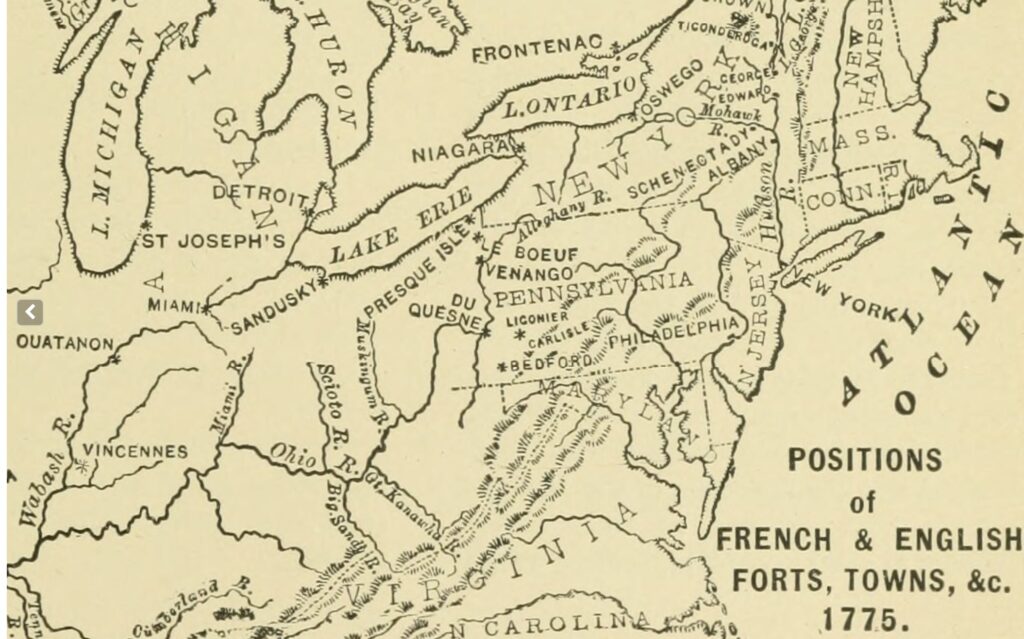
• The Forks of the Ohio (Fort Pitt / Pittsburgh): the gate to the Ohio River and the valley beyond. Whoever controlled the Forks controlled the funnel through which soldiers, traders, and speculators poured westward.
• Redstone Old Fort (Brownsville, PA): Redstone Old Fort (Brownsville, PA): Situated along Nemacolin’s Trail, later called Braddock’s Road, Redstone first became a supply hub when William Trent built a storehouse there in 1754. Its position on the Monongahela made it a natural staging ground: wagons could reach the river, transfer goods, and drift toward the Ohio. After the Seven Years’ War, the stockade erected by Colonel James Burd in 1759 was known as Fort Burd, while the older name Redstone Old Fort continued to be used. Crucially, Redstone stood atop an ancient Native earthwork. “Old Fort” wasn’t a nod to an out-of-use colonial garrison; it was a settler label for the mound. However, while colonial settlers assumed it belonged to the ‘Mound Builders’, archaeologists have not definitively assigned it to a specific tradition such as Adena, Hopewell or Fort Ancient. What is clear is that the landscape it crowns had been shaped by humans long before eighteenth-century towns.
• The Cumberland Gap: Far to the south, where Kentucky, Tennessee, and Virginia now touch, a narrow break cut through the Appalachian range. In 1774 it was a recent addition to colonial geography—known but still perilous, and far from the open door later memory imagined. For settlers it offered a southern key into the interior; for Native nations it was simply one of the old corridors leading toward the hunting grounds colonists would call Kentucky.
• The Rivers themselves: the Monongahela, Kanawha, Muskingum — the back doors, waterways without which no heavy freight could move.
This is why control of chokepoints equaled control of the Valley. Whoever held Fort Pitt, Redstone, or the Gap dictated who got in and on what terms. It’s also why the fiction of terra nullius was so corrosive: Europeans declared the land “empty,” yet every path west was in fact gated by geography and guarded by Native power. To cross into the Ohio was never free passage — it was negotiation, trespass, or conquest. Once it could be reached, the Ohio River represented a vital artery for trade, colonization, and disease – two of those outcomes proving devastating for Native populations.
Ohio River Valley Breached: Invasion, Disease, Disruption
“Nothing, said White [Eyes], had equaled the decline of his tribe since the white people had come into the country. They were destroyed in part by disorders which they brought with them, by the small pox, the venereal disease, and by the free use of spirituous liquors…”[5]
The Ohio Valley, once protected by mountains and distance, was now exposed; once the gates were breached, sickness poured through Native towns with devastating speed. The mountains had protected the peoples of the valley from epidemics up until this point in history, so now diseases common in Europe tore through communities that had no acquired immunity to them whatsoever. Smallpox, measles, scarlet fever, and influenza came in wave after wave. Physical anthropologist Lorraine P. Saunders’s study of a Seneca cemetery—discussed by Henry Dobyns in his demographic analysis—shows that nearly half of those buried during epidemic periods were adolescents.[6] Similar patterns appear in nineteenth-century census records from Plains tribes. Disease fell hardest on the young, cutting into the very demographic future of Native communities.
The breach also came in the form of axes and rifles. Settlers, surveyors, and trappers pressed westward, bringing overhunting, deforestation, and depletion of game. Deer, turkeys, elk, turtle, and bison had been central not only to subsistence but also to trade and ceremony. By the 1770s, Native leaders had already been warning colonial officials that game was vanishing, a concern preserved in council speeches and treaties. Settlers, by contrast, treated the animal herds in particular as either obstacles or inexhaustible quarry.
One story, preserved by Lucullus McWhorter and reprinted in the Hacker’s Creek Journal, captures the mindset: when John Hacker found his corn ruined by buffalo, he chased the herd into what is now Holly River State Park and slaughtered them.[7] Frontier memory later praised the act as grit; read today, it’s a parable of destruction.
The dead, too, were no longer safe. As James Adair observed, Native nations buried their dead with material goods and never disturbed them, “even a bloodthirsty enemy will not despoil or disturb the dead.”[8] John Heckewelder echoed the point, noting that Native peoples would never desecrate the ashes of the dead, even of their enemies.[9] Settlers brought a different ethic. Euro-American farmers plowed over Native cemeteries, fenced them off, and turned them into crop fields. Antiquarians admitted to digging recklessly into the earthworks, but the more ordinary graves of the Shawnee, Lenape, Mingo, and others disappeared first, claimed not by shovel but by plow. Even the spirits of the valley were not spared once the Ohio was breached.
Conclusion
For the Native peoples of the Ohio River Valley, the 1770s marked a significant turning point, marking a break with everything their ancestors had known. The graves of the dead, once inviolate even in times of war, were plowed under and fenced through. The hunt, once guided by spiritual obligation and communal restraint, was reduced to a scramble shaped by markets and settler disruption. Disease, against which no memory or medicine could protect them, cut deepest into the young, stripping whole villages of their future. For the first time, the foundations of Native life in the valley — reverence for the dead, balance with the land, and confidence in the renewal of generations — were all under assault at once.
Looking Ahead
This will not be the last post where I consider the impact of the prehistoric to protohistoric mound-building peoples — the Adena, Hopewell, and Fort Ancient. By the time Europeans arrived on the Ohio, these societies were long gone, their earthworks already part of a layered historical landscape. In a later post, I will explore how those mounds shaped settler imagination, serving as both monuments of a deeper past and justifications for conquest. In this post, however, I want to shift the focus to the river itself. For Native peoples, the Ohio was a sustaining corridor, a path of trade, diplomacy, and memory. For colonists, it became something else: a line to be crossed, mapped, and claimed as terra nullius, a pathway for empire.
Notes & Citations:
[1] Drake, Samuel Adams. The Making of the Ohio Valley States, -1837. New York, C. Scribner’s Sons, 1894. Pdf. https://www.loc.gov/item/01006628/. 115.
[2] Bradley T. Lepper, Early Historic American Indian Testimony Concerning the Ancient Earthworks of Eastern North America (Columbus: Ohio Archaeological Council, 2016), 3, https://ohioarchaeology.org/file_download/inline/fe744ef3-f595-44ae-acd5-b0a1cddecce4.
[3] Patricia Springborg, ‘Hobbes, Donne and the Virginia Company: Terra Nullius and’ the Bulimia of Dominium’, History of Political Thought 36, no. 1 (2015): 144.
[4] Alanson Buck Skinner, Two Lenape Stone Masks from Pennsylvania and New York (New York: Museum of the American Indian, Heye Foundation, 1920), HathiTrust Digital Library, https://catalog.hathitrust.org/Record/103285362
[5] John Heckewelder, An Account of the History, Manners, and Customs of the Indian Nations Who Once Inhabited Pennsylvania and the Neighboring States (Philadelphia: Abraham Small, 1819), https://www.gutenberg.org/files/50350/50350-h/50350-h.htm
[6] Henry F. Dobyns, Their Number Become Thinned: Native American Population Dynamics in Eastern North America(Knoxville: University of Tennessee Press in cooperation with the Newberry Library Center for the History of the American Indian, 1983), https://archive.org/details/theirnumberbecom0000doby/page/n3/mode/2
[7] Hacker’s Creek Journal. Vol. 10 (1991–1992). Horner, WV: Hacker’s Creek Pioneer Descendants, 1992.
[8] James Adair, The History of the American Indians (London: Edward and Charles Dilly, 1775), 182.
[9]Heckewelder, An Account of the History, Manners, and Customs of the Indian Nations Who Once Inhabited Pennsylvania and the Neighboring States
For readers who wish to follow ongoing research, subscription is available in the footer.